This Kickstarter is meant for those interested in pushing technology towards the service of humanity, meaning (OTMP) "Other-Than-Military-Purposes." I offer the rewards to make it compelling, but I'll make accommodations to backers if possible for unconventional rewards so long as they comply with kickstarter rules.
This machine is specifically designed for the purpose of conducting humanitarian, environmental and academic work. This is to be done through long duration flights carrying a useful payload. That means starting with a proof-of-concept Kickstarter (first of three), to prove these ideas worthy of your continued backing.
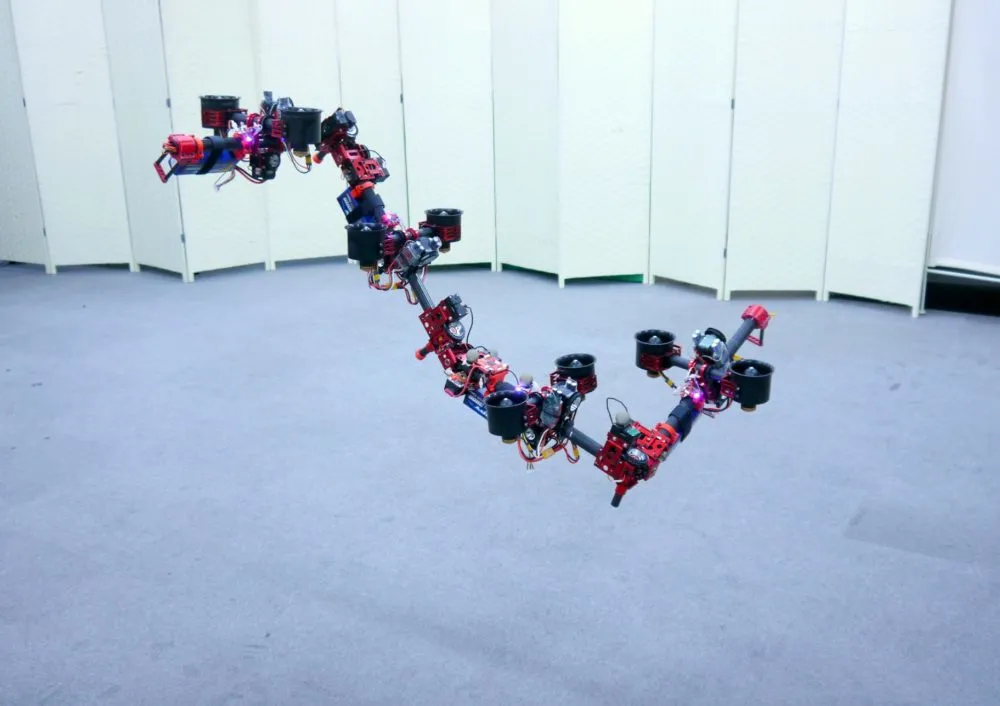
That's all easy to say, but how are we to actually do it ? Tilt-rotors !
* Lion = Lithium Ion battery, LiPo = Lithium Polymer battery.
As for the common multirotors (even expensive large ones), all have limitations of payload and duration of flight. As these are the measures of any flying machines usefulness, improvements in these capabilities must be demonstrated for these aerial robots to be considered more than just an expensive, novel toy.
Second, sensory systems must catch up, and be made small and yet still effective. The sensory system of this proposed machine would be modular, capable of being tailored for each flight and users needs. ( More on that below. )
(In the title pic you'll see a 3rd generation Tri-Copter, very successful.)
Like myself, you want to be a rebel with a cause! Instead of passively reading and watching terrible events in the world, lets go! Seize the initiative and use technology that humanity has never possessed before, and use it for good. Developing drones for other than military purposes wont be easy, but it will be worth it !
.
This will take place at Shasta College via independent study courses, my own time and money, and involve local businesses that have assisted my past multirotor efforts.
.
Ohlone, Shasta and CSU Chico.
Already flown sensors include temperature, humidity and NVDI pictures. These sensors have returned valid data on many flights. End users, like universities, private individuals and government agencies may like to develop there own unique sensors. This machine is envisioned from the beginning to be open source friendly, so integration of new sensors will be easy.
Modular Sensory Systems (as many as possible will be flown) :
* The Lidar and GPS features are most difficult to implement, these may have to wait for the second Kickstarter.
^ this is expensive and may have to wait for the second Kickstarter.
^ Medical supplies are often small yet valuable and needed quickly by nurses and doctors where there are no or few roads.
In future versions sensor data captured would be assigned at least one method of retrieval from the bot itself. This means solid-state memory or real time transmission to ground.
For agricultural use, Ive been using NVDI (Normalized Vegetation Difference Index) to evaluate plant health from a distance. Using NVDI, large sections of crop or forested areas could be measured for disease prevention instead of disease suppression after the fact.
At Shasta College in particular, we are investigating whether random flights of UAVs could be used to prevent crop loss. ( Chasing animals off, without hurting them. ) Furthermore, a great deal of water is lost In California's central valley and drought is a particular problem. Aerial detection of leaks would be advantageous, and it adds up.
For future versions of this machine, we want to take part in research geographic information system (GIS) efforts shown below. Launching from a large ocean-going research ship, making measurements, and returning. (At least experimentally for now) However, this would necessitate flights of several miles which isn't possible yet. ( We'd need the third starter !)
Capturing many far off data points allows for greater science at lower cost, compared to a slow moving ship with single measurements from its path of travel. Surface vessels and or low altitude drones can evaluate pollution that otherwise cant be seen from satellites. In the above picture, the temperature colorized map is obtained via satellite, however the only means of measuring harmful radionuclides, PCBs or DDT would be through direct sampling of water of surfaces. Remote sensing from orbit down to Earth's surface would allow for comprehensive models of various kinds.
Measuring the bio-accumulation of poisonous chemicals is becoming increasingly important in third world countries, largely do to poor practices in power generation and electronic waste. Rivers and small water ways are known to transport poisonous chemicals quickly.
Ultimate success will be measured by the ability to travel fast and far, stay on station, and bring back information. For example, A squadron of 10 UAVs could range out far and wide from a ship, take subsurface samples measure and return tracking radioactive or poisonous materials. Medicine could be delivered fast to an outbreak that is far from other transport. War crimes could be observed by accredited journalists at a safer distance and faster than a cover-up could take place. (For example, Syria's use of chlorine and ammonia, or the use child soldiers in Africa)
For the rewards of $120 and above, Ill print and fabricate composite parts for two sizes of machines, either the 450 or the 600 size. This means the servo tray, the landing gear and other parts needed, servos not included. list of materials and where to buy included. (basic machine and does not include my advance systems.) These rewards are for those who have built similar multi-rotors in the past, not those new to the hobby.
(Jan 28 2015 to July 15 2015)
like the Neato XV-11 LiDAR, and Kinect bounties, I feel modularity is wise and open "hackability" essential. University researchers and humanitarian users shouldn't have to fight a closed unsupported system. http://letsmakerobots.com/blog/gallamine/open-lidar-project-hack-neato-xv-11-lidar-400-bounty
Land mine detonator: https://www.kickstarter.com/projects/massoudhassani/mine-kafon
Public Lab: https://www.kickstarter.com/projects/publiclab/infragram-the-infrared-photography-project
Pixy cam: https://www.kickstarter.com/projects/254449872/pixy-cmucam5-a-fast-easy-to-use-vision-sensor
Rainforest Connection: https://www.kickstarter.com/projects/topherwhite/rainforest-connection-phones-turned-to-forest-guar
This first Kickstarter ($1,200) demonstrates the tilt-rotor ability, greater efficiency and the beginnings of a modular sensor system. (This first kickstarter does not need any FAA certification) This will be a tiny tilt-rotor, about the size of whats seen in the above pictures.This is a proof-of-concept device.
The second Kickstarter (approximately $8,000) will improve the power supply for longer range flight without the use of LiPo batteries for main power. This power units details will be released for backer review, but for now its secret for technical and legal reasons. (This version will not need waivers from the FAA) This is a technology demonstrator using collective pitch propellers.
The third Kickstarter (approximately $70,000) will make long range flights at sea of several miles and back. ( sea flights for safety and verification of GPS waypoint navigation.) This machine will be capable of scientific and humanitarian flights into disaster areas and is a large tilt-rotor
Ive chosen three separate Kickstarters to prove my self capable of the skills and ideas I claim. Furthermore, the backers benefit from transparency, which allows the backer to re-evaluate whether this project is right for them at each stage.
Test Point One: Can tilting be done with practical dimensions, and mass ?
Test Point Two: Does tilting increase flight distance per unit of power consumed ?
Test Point Three: Is there a measurable difference between LiPo or Lion batteries in forward flight ?
Test Point Four: Can a tilt-rotor carry and use modular instruments across water and fields ?
Test Point Five: Can this machine carry a dead-weight equivalent to the second Kickstarters advanced range power unit ?
* Lion = Lithium Ion battery, LiPo = Lithium Polymer battery.
The greatest risk is large national defense contractors trying to take over this industry, while we are newborn still in the crib.
And a close second, the FAA dragging its feet in allowing the safe use of drones for profit. It looks very much like Australia is leading the way for the use of multirotors by small and midsize companies. Perhaps we Americans, for the first time, are giving up the initiative on an all new frontier, which we are not known for.
Next, with every flight, the agricultural use seems more and more practical. Ive been getting good NDVI pics from on-board.
A significant challenge I frequently see is scattered information. Many projects claim to inform you on the ability to build your own multi-rotor, but skip key material and setup guides. There is also problem in the other direction, the dumping of a lot of random information on the you the end user, and your left to randomly sift through it.