|
Aerial Video |
Aerial Real-Time Surveillance | Aerial Mapping System | |
|---|---|---|---|
| Weight | 1.7 - 2kg | 1.7 - 2kg | 1.7 - 2kg |
| Ceiling Altitude | 120m(AGL) | 120m(AGL) | 120m(AGL) |
| Cruising speed | 54 - 63 Km/Hr | 54 - 63 Km/Hr | 54 - 63 Km/Hr |
| Weather |
Beaufort Scale 4 |
Beaufort Scale 4 |
Beaufort Scale 4 |
| Take off | Hand Thrown Launch | Hand Thrown Launch | Hand Thrown Launch |
| Landing | Stall Landing | Stall Landing | Stall Landing |
| Propulsion | Blushless Electric Motor | Blushless Electric Motor | Blushless Electric Motor |
| Endurance | 40+mins | 40+mins | 40+mins |
| Height above take off location (AGL) | 120 m | 120m | 120m |
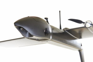
| Camera |
Dual HQ Video ( front/down view ) Photo Mode for Mosaic Mapping 1080P , 60FPS |
HQ Video + 5.8G FPV 1080P , 60 FPS 5.8G ,32CH, LCD Monitor |
Digital Camera Ricoh WG-5 (or equivalent) 16 Mega pixels / 25mm / f 2 |
| Application |
Aerial Mapping Disaster Emergency Works Supervision Agricultural Survey Forest Monitoring |
Aerial Mapping Disaster Emergency Works Supervision Agricultural Survey Forest Monitoring |
Aerial Mapping Disaster Emergency Works Supervision Agricultural Survey Forest Monitoring |