Aerial Image Collection
Compared to traditional methods of gathering aerial images Unmanned Air Systems will provide you with a low cost alternative without compromising on quality. Using an appropriate UAS and processing software it is possible to generate Geo Referenced aerial imagery with resolutions of up to 2.5cm/pixel resolution.
Survey
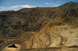
Using this imagery it is also possible to produce accurate 3D Ortho-mosaic models in about 10% of the time it takes to conduct a traditional survey.This efficient method of collecting data makes it possible to conduct volumetric measurements for mining and quarry operations on a more regular basis allowing a greater degree of accuracy on production figures.
Gathering aerial imagery of large construction projects to measure progress can be done with ease.


")