
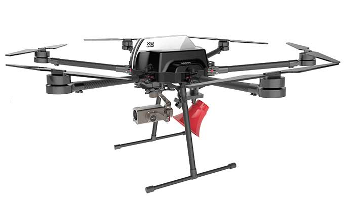
用于测量,检查,3D重建和高细节激光扫描的重载解决方案。


每个无人机专业的有效载荷
Multiruolo IR / RGB
高精度自适应万向节,设计用于携带不同类型的传感器,配备高分辨率IR / RGB双室,优化用于航空摄影测量,技术检查,调查。
- Sony 20mpx RGB相机,Zoom 3x / 18.9mpx,Zoom 30x,4K / FHD Zeiss optic
- 具有不同分辨率和光学等级的IR Thermal Flir腔室,具有辐射功能 - 由无刷编码器电机驱动的360°运动。
- 带地理标签的自动或手动远程触发器
- 带远程开关的Live Out HD数字Ir / rgb
- 红外摄像机功能(变焦,颜色,照片或视频)。
- RGB摄像机设置远程管理(可选)。

每个无人机专业的有效载荷
Multiruolo IR / RGB
高精度自适应万向节,设计用于携带不同类型的传感器,配备高分辨率IR / RGB双室,优化用于航空摄影测量,技术检查,调查。
- 索尼42兆像素4k RGB相机,蔡司光学
- IR Thermal Flir腔室,具有不同的分辨率和光学等级,具有辐射功能
- 由无刷编码器电机驱动的360°运动。
- 带地理标签的自动或手动远程触发器
- 带远程开关的Live Out HD数字Ir / rgb
- 红外摄像机功能(变焦,颜色,照片或视频)。
- RGB摄像机设置远程管理(可选)。

每个无人机专业的有效载荷
AGRO多传感器
High precision adaptive gimbal designed to carry different types of sensors equipped with triple IR camera / RGB / Multispectral high resolution, optimized for precision farming able to return 3 different information (terrestrial orography, vegetative vigor, water stress).
- 20 megapixel Sony RGB camera with zeiss optics and 3X zoom
- IR Thermal Flir chamber with different resolution and optical gradations with radiometric functions
- Multispectral camera with 5-band global shutter sensor (blue, green, red, near IR, Red edge), with light correction via DLS sensor
- 360 ° movement driven by brushless encoder motors.
- Automatic or manual remote trigger with geo tag
- Live Out HD digital IR / RGB with remote switch.
- IR camera functions (zoom, color, photo or video).
- RGB camera settings remote management (optional).

payload lidar per drone professionale
LIDAR Payload
Lidar system for surveys and real-time return of high density point clouds, particularly recommended for DTM surveys in the presence of vegetation and reliefs of artifacts and complex infrastructures, the system can also be used as a ground instrument (backpack, car).
- 16-channel VOD16 velodyne sensor
- GPS PPK or RTK receiver gps glonas
- Integrated high precision inertial platform
- Approximate accuracy to ground 5 cm

payload thermal per drone professionale
Sistema GNSS RTK PPK
Turnkey system optimized for GPS coordinates data sending, accuracy by centimeters, which, inserted on a 3D processing software produces high-precision geo-referenced 3D models.
它可以在PPK模式下工作,记录坐标一旦使用提供的软件处理,就可以用于地形使用或RTK模式使用地面站,实时地使无人机的导航精确生成已经处理的坐标。
该套件包括
- 带RTK天线和遥测数据链的集成板载设备。
- 带RTK天线,数据链,高自主电池,三脚架和平板电脑支架的地面站。
- Android坐标处理软件 - Windows。


")